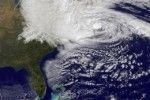
The Northeastern U.S. experienced history in the making as the unlikely Superstorm Sandy made landfall Monday night. Sandy was regarded as having unprecedented storm potential due to a threatening combination of natural events.
For New York City at least, Sandy was not the days-long onslaught many had feared, and the wind and rain that sent water sloshing into Manhattan from three sides began dying down within hours.
Power went out for hundreds of thousands of New Yorkers and an estimated 5.2 million people altogether across the East. The full extent of the storms damage across the region was unclear, and unlikely to be known until daybreak, a according to The Associated Press.
Late-season hurricanes affecting the U.S. are very uncommon, said Don Conlee, professor in the Department of Meteorology. Typically, tropical cyclones in the north Atlantic especially this late in the season would not be heading in the direction that Sandy is moving. Its impressive that they have been able to predict this unusual motion so far in advance.
New York City resident Rebecca Haughey, Class of 2011, and her husband have braced themselves for the worst.
Were not in an evacuation zone, although were about a block from the East River, Haughey said. My husband went out this morning when it was more calm and he saw FDR Drive [the highway along the river] flooded.
Conlee said part of what makes Sandy so different from other storms aside from its strength this late in the season is the interaction it is having with mid-latitude weather. He said because Sandy has such a large circulation that numerous surges will accompany it.
Erik Nielson, senior meteorology major, interned at the National Hurricane Center in the summer of 2012 and is following the storm closely.
With [Sandy] going into New York it is a different situation because this area is not used to getting hit with this kind of weather, Nielson said. Its not necessarily related to the category of the storm, but the geography of the basin that its hitting. As this system moves into land its going to spread out, slow down and drop huge amounts of rain on the area.
Nielson said he would caution people who think they can wait out the storm by not evacuating.
They did get hit by Hurricane Irene last year but this is much different and much more powerful, Nielson said. People shouldnt think that just because they survived Irene they will be able to survive Sandy. Every storm is unique and you cant compare them, even if they are the same category.
For this particular system, national advisories are not being sent out.
This is a complex situation, Conlee said. They have decided to let each weather service office issue its own warnings. They are handling it as if it were local.
Jeff Lindner, a meteorologist working for the Houston flood control, said the models are doing a good job of predicting the track of this rare pattern. The current model posted by the National Hurricane Center states the tracks for Sandy all point toward the storm stalling inland on Tuesday, which will significantly affect recovery in the severely effected areas.
Avery Tomasco, sophomore meteorology major, said Sandy will likely be studied and remembered years after its fruition.
Sandy is the storm of a lifetime, Tomasco said. The combination of high tide and a steering current pushing this storm straight into the most densely populated region in the U.S. will make for a rare event that everyone should pay close attention to. Hurricane Sandy will be among the most famous storms ever to hit the U.S.
Superstorm Sandy slams into NYC
October 30, 2012

0
Donate to The Battalion
$1815
$5000
Contributed
Our Goal
Your donation will support the student journalists of Texas A&M University - College Station. Your contribution will allow us to purchase equipment and cover our annual website hosting costs, in addition to paying freelance staffers for their work, travel costs for coverage and more!
More to Discover


