Texas A&M University Agrilife Research and Extension Center in Corpus Christi was granted the first Certificate of Authorization permit to use drones, also called unmanned aerial vehicles or UAVs, to conduct agricultural research on crops.
With the permit from the Federal Aviation Administration, the Agrilife Extension office at Corpus Christi plans to research how quantities of nutrients, irrigation and drought and diseases affect crops in real time.
Juan A. Landivar, resident director of the Corpus Christi Agrilife Extension office, said the FAA finally granted authorization nearly a year after they applied for it.
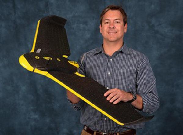
The UAV used, called a SenseFly eBee, is a fixed wing platform that acts like a miniature plane. The drone is composed of a flexible plastic material. The two cameras used to gather images and information are a normal red-green-blue camera for images, Corpus Christi Agrilife Extension has also submitted paperwork applying for a helicopter-type drone permit.
The goal for using drones in agriculture is to ultimately improve crop yields and livestock management by integrating agriculture with precision databases and remote sensors on the drones.
Michael Starek, the research’s specialist on Geographic Information Science and Geospatial Surveying Engineering, is using gathered data to see how the sensors on the drone process information.
“The idea is really to look at the potential of the technology. We want to look at the flight design, what wind does when you fly and how does that affects the data accuracy that you get,” Starek said. “We’re trying to figure out the most efficient ways to collect this data and process it. Ultimately we want to progress the potential of this technology for the end users — agriculturalists and farmers.”
There are two types of cameras mounted onto the UAV itself, and from the images collected researchers are able to determine either geospatial imaging or near-infrared wavelengths. From this data, researchers are able to not only monitor growth of crops in a 2-dimensional image, but 3-dimensional imaging as well. Near-infrared imaging can indicate which plants are not faring as well as others.
The main crop in consideration with this research is cotton, and the main problem of the cotton industry is root-rot.
“Remote sensing has proven to be very useful in identifying field areas where the crop is stricken with this disease,” said Alex Thomasson, engineering professor. “Once those areas have been identified, an effective fungicide that has recently been approved for use by EPA can be applied in subsequent years in only those areas, greatly reducing overall cost and minimizing environmental risk.”
Plans to eventually use software on drones to determine things such as phenotyping in crops and rangeland forage density are underway. Other crops that the Agrilife Extension hopes to work with include citrus orchards, in order to study the effects of a disease called citrus greening, and vegetable crops.
“I think the real advantage is ultimately farmers can go out and get the data when they need it,” Starek said. “One day I imagine there will be swarms of these things. The farmer can just go out in the morning and fly before they’re about to water their thousands of acres of crops, or know where to drop insecticide. They’ll be able to say, do this area and not this area. It will really increase efficiency.”
First to fly
February 26, 2015
Provided.
Michael Starek holds the SenseFly eBee, a fixed wing platform that acts like a miniature plane.
0
Donate to The Battalion
$2065
$5000
Contributed
Our Goal
Your donation will support the student journalists of Texas A&M University - College Station. Your contribution will allow us to purchase equipment and cover our annual website hosting costs, in addition to paying freelance staffers for their work, travel costs for coverage and more!
More to Discover


